San Francisco Peaks Ranger District Wilderness Areas Volunteer Manual
Fall 2012, Wilderness Management
John Ehlen, Joseph Hill, Katelynn Jenkins, Ryan Scott, Buck Skowronek
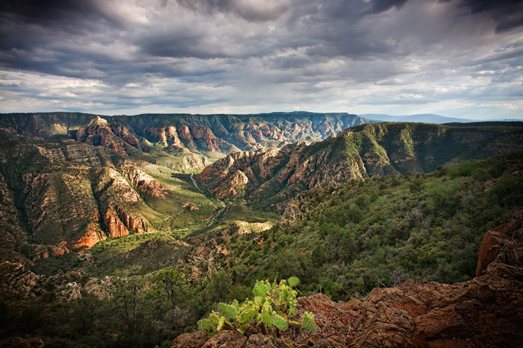
Photo Credit: (http://flagstaffartistsgallery.com/ArtistPages/CoyleJoe/Sycamore-Canyon.jpg)
Introduction
The US Forest Service as a federal agency relies heavily on volunteer work as a main factor in developing an organized and successful management system. Volunteers are used for a variety of projects within a diverse selection of Wilderness areas to apply their individual skill sets to. USFS volunteers have restored Cliff Dwellings in New Mexico, surveyed sites for Wilderness nation-wide and have managed for invasive plants species and ecological impacts of anthropogenic use in rare and delicate life zones that exist in the Kachina Peaks Wilderness here in Arizona. Projects may consist of satisfying a single day objective to working towards a long-term goal. Regardless of the work involved, volunteers experience a plethora of rewards and gain experiences, networking and skills unlike those learned anywhere else. Therefore, Wilderness Volunteers must be prepared with all of the essential tools and knowledge to ensure that management practices are effectively implemented and all precautions for health and safety are adequately met. It is guaranteed by the USFS that volunteers have the right to work in a safe, friendly and healthy working atmosphere. One method to satisfy these rights is through volunteer education and preparation with a go-to document that will help to reinforce volunteer stewardship standards and build public knowledge of the Wilderness that surround the Flagstaff area. Thus the Flagstaff Ranger District Volunteer Manual is presented within this report for the USFS to use as a tool for volunteer training and education. Volunteers cannot be blind in the field and this manual incorporates all the general information, trail guides, conduct protocol and even orienteering training. This comprehensive manual will set a standard for the Flagstaff Ranger District and in effect maximizes volunteer utility. It constitutes protocol of the volunteer position, making education clear and easy to access and in effect will influence strength in individuals who donate their time as well as the number of those who volunteer in the first place.
Methods
The steps to completing this manual are simple in description, but extensive in execution. The first part of the process included a brainstorming phase where we conferred with US Forest Service managers Justin Loxley and Patrick McGervey to develop a basic outline for the volunteer manual. The outline consisted of majors sections needed to complete the manual. With the help of the managers, we divided the sections among crew members. Next, each crewmember researched their topic through internet sources and sources provided by the managers. Many of the trail descriptions and maps were taken directly from the USFS website. Drafts were produced for each section and turned into Justin for feedback. Once the feedback was received, corrections were made and the final manual was completed.
Results
Coconino National Forest
The Coconino National Forest, located in Northern Arizona, is 1.8 million acres and entirely surrounds the cities of Flagstaff and Sedona. The forest also borders four other national forests: The Apache-Sitgreaves national forest to the south-east, The Kaibab National Forest to the North and West, The Prescott National Forest to the south-west, and the Tonto national Forest to the south. There are a wide variety of landscapes in the forest including alpine tundra’s, deserts, flatlands, mesas, ponderosa pine forests, and volcanic peaks. Elevations in the forest range from 12, 633 feet at Humphrey’s Summit too nearly 2,500 feet in some parts near the Verde River. The Coconino National Forest is divided into three districts: The Flagstaff District, The Mogollon Rim District, and the Red Rock District. Each area has its own distinct geography and environment. The Flagstaff Ranger District encompasses nearly 850,000 acres of National Forest lands around the Flagstaff area, from Mormon Lake and Anderson Mesa to north of the San Francisco Peaks. The Mogollon Rim is a rugged escarpment that forms the southern limit of the Colorado Plateau. It extends across the entire forest and provides excellent views within Plateau Country and Desert Canyon Country as well. The Red Rock District includes nearly160,000 acres of buttes, pinnacles, mesas, and canyons and is world renowned for its red rock vistas. Vegetation type is heavily dependent on elevation and location in the forest. Conifers and Evergreens are the main flora found in the Forest. Deciduous trees are rarely found, except in some moist areas near creeks and streams. The most common species found throughout the forest is the ponderosa pine.
Coconino National Forest Wilderness Areas
Sycamore Canyon Wilderness
Sycamore Canyon Wilderness is located approximately 25 miles, as the crow flies, southwest of Flagstaff, Arizona and about 16 miles northwest of Sedona, Arizona. It is bordered to the southeast by the Red Rock-Secret Mountain Wilderness. The very popular tourist attraction of Oak Creek Canyon is located 13 miles to the east. The Wilderness is accessible from the west by way of a few US Forest Service roads, and to the east by US Forest Service roads leading to all major trailheads for Sycamore Canyon. The Sycamore Canyon Wilderness covers 55,937 acres of extremely rugged and primitive country. In round numbers, the canyon is approximately 1,500 feet deep with the average elevation of the rim of canyon being 6,000 feet, and the bottom of the canyon measuring at about 4,500 feet in elevation. Obviously there is considerable variability when it comes to the topography of the canyon. The canyon is just over 20 miles long and starts at the Colorado Plateau and empties into the Verde Valley. Due to the sheer size and length of Sycamore Canyon, there are many vegetation types located within it. Near the upper reaches of the canyon, the dominant vegetation type is a ponderosa pine and fir forest with Gambel oak and multiple juniper species intermixed throughout the forest. The vegetation type in the bottom the canyon is much different from the rim due to the fact it is lower in elevation and because it is a riparian area. The dominant vegetation type in the bottom is comprised of mainly deciduous trees such sycamore, ash, and oak. The water supply in this riparian area is an ephemeral creek, and water is typically only flowing during the wet seasons or during spring runoff. There are deep pockets along the canyon where water will be available all year even when the creek is not running. Near the end of the canyon where it reaches the Verde Valley, the elevation is lower and vegetation type transitions from the pine/fir forest to a high desert type. It can be considerably hotter and drier near the Verde Valley than the where the canyon begins up in the high country. Many species of animals can be found within the Wilderness. Elk, mule deer, and Coues deer inhabit the canyon, with the highest populations occurring in the winter when snowfall forces them to lower elevations in search of available feed. While there are some resident elk and mule deer, a large portion of them will migrate out of the canyon in the spring, once the snow begins to melt. The Coues deer however, are typically year round residents of the canyon. Other species located in the Wilderness include bears, mountain lions, coyotes, foxes, raccoons, skunks, ring-tailed cats, and other small mammals. Reptiles such as rattlesnakes, horny toads, and lizards also make Sycamore Canyon home. The riparian habitat is a major attraction for a number of wild birds. The dominant use of the Wilderness is primitive recreation. Hunting, hiking, horseback riding, and camping are the most popular activities for recreationists. Recreationists are restricted by wilderness regulations that prohibit the use of mechanized equipment such as motorized vehicles and mountain bikes. If livestock is to be used, they must be fed weed seed free hay to prevent the spread of invasive plant species. As always, the concept of leave no trace is in effect for visitors. The amount of visitor use is not well documented.

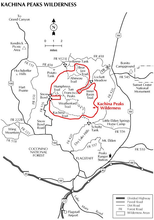
Kachina Peaks Wilderness
Strawberry Crater Wilderness
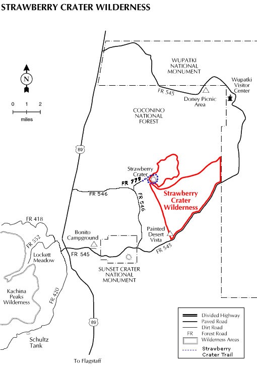
Access: Sunset Crater/Wupatki Road (FR 545) borders one side of the Wilderness. Additional access is provided by FR’s 546 and 779 off US 89 at the bottom of the north slope to the pass between the San Francisco Peaks and O’Leary Peak.
Kendrick Mountain Wilderness
Pumpkin Trail: The Pumpkin Trail offers the visitor a long hike from a valley of pine and junipers up through mountain meadows and forests of mixed conifer, aspen and fir to the summit of Kendrick Peak. All of the hike is within the Kendrick Mountain Wilderness. The upper three quarters of it follow the alignment of an old sheepherder route used up to 40 years ago. The remains of an old sheepherder’s cabin still stand alongside the trail about 1/4 mile below the lookout tower. Note that there are no reliable springs along the trail and no water at the top of the mountain. Initially, this trail follows an old road then rises along a steep canyon. After passing through a gate, the trail ascends a ridge, gradually turning southeast. From here to the top of Kendrick Mountain, the trail follows a ridge through meadows, aspen and conifer stands. Rock cairns often show the way. All of the trail is within the Kendrick Mountain Wilderness. It is possible to link up with the Bull Basin Trail via the Connector Trail for an 11 mile hike.
Wilderness Stewardship Challenge
The Wilderness Stewardship Challenge was introduced in 2004 as an effort to raise accountability standards of stewardship within the wilderness lands that the Forest Service manages. Today, the Forest Service manages over 400 designated wilderness areas, making this process quite the challenge. By participating in this volunteer program, you are helping the Forest Service reach its goal by completing a few key elements that are part of the challenge. In total there are ten elements that have been identified as essential in the effort to assure wilderness preservation under the Forest Services’ management indefinitely. The following elements exemplify the qualities of volunteers and how they relate to the Flagstaff Ranger District.
Purpose for the Wilderness Volunteer Position
The purpose of the volunteer position with the Coconino Forest Service is to support several levels of the USFS Chief’s Wilderness Stewardship Challenge. The elements addressed by this volunteer program include:
- Element 2 – Invasive plants are successfully treated
Volunteers are expected to learn about and be able to identify the invasive species of plants that have come to the Flagstaff and Coconino region to call home. This knowledge and skill is used in order to locate and further monitor any invasive plant species populations for scientific study and aids wilderness management in preserving and restoring a healthy forest ecosystem. The Flagstaff area can see invasive plant species such as cheatgrass and sweet clover.
- Element 6 – Recreation site inventory is completed
Volunteers are expected to be able to know how to monitor visitor and recreation sites while recording pertinent data that help wilderness management examine human influence on our natural forests and how negative influences can be mitigated and more ideally prevented. Volunteers utilize “national site monitoring protocol.” Flagstaff Ranger District Wilderness areas are subject to different forms and quantities of use. Volunteers are expected to understand how to monitor busy trails at the Kachina Wilderness while monitoring for solitude at Strawberry Crater Wilderness.
- Element 10 – Wilderness has in place a baseline workforce
Objectives of the Forest Service can only be accomplished through a strong and well-organized workforce. Volunteers are the most essential component of this element as they are the heart of a strong managing work force. Only through your effort will the Stewardship challenge be successful, and by volunteering you are helping to assure that over 35 million acres of designated wilderness is protected for generations of future use and you are also helping to educate the public about the importance of these dynamic and majestic locations. The Flagstaff region is home to some of the most beautiful and most ecologically complex wilderness environments, therefore making volunteers a critical aspect in educating the public about these unique places.
Position Description for Wilderness Volunteers
What to expect from the position:
- Must have a flexible schedule, trips can be changed due to weather, fellow worker’s work schedules, and other wilderness duties.
- Volunteers are matched to a project that fits their strengths and skills to help the Forest Service accomplish their mission.
- Should be able to work well in teams or individually depending on the task
- Each wilderness trip is usually a day trip and some overnight trips might be asked, depending on the individual’s leisure time.
- Volunteer must have a friendly, professional demeanor when communicating with visitors.
- Volunteers should be able to carry a pack could weigh up to 50 pounds and be expect to hike long distances during the duration of their trip
Description (what you are actually going to do)
- Volunteers are going to be working with the Forest Service on a variety of tasks, including: Trail restoration, Water Quality, Removal of Invasive Species, and educating visitors on the importance of preserving wilderness areas.
- Walking trails to make contact with visitors to inform them on the Leave No Trace principles to minimize their impact on the wilderness.
- Volunteer may also be trained to issue backcountry permits to hikers during the winter months.
- Visitor counts will also take place in campsites to ensure that the wilderness is not becoming overcrowded, so each visitor can experience a feeling of solitude.
- Volunteers can train to become ambassadors to help the Forest Service and other government agencies to maintain motorized trails, educate people about Off Highway Vehicles and outdoor ethics.
Position Orientation Material
- Good communication skills with visitors and co-workers
- Positive, helpful and friendly attitude
- Good hearing for interacting in face-to-face contacts
- Ability to drive on gravel, dirt and paved roads in all weather conditions for several hours
- Lift 35 – 80 lbs. to shoulder level (example: saddles, packs, tools, logs, etc.)
- Good communication skills with visitors and co-workers
- Able to do a variety of tasks using common tools (i.e. fence repair, digging, installing signs and posts, bucking up downed trees with cross-cut saw, shoveling manure, etc.)
- A valid driver’s license and good driving record
Things You Need To Know:
- Attitude. The Volunteer Program needs people who have a genuine interest in helping the Forest Service pursue its mission: “Caring for the land and serving people.” Volunteers who get the most from the program are those that have a true Volunteer Spirit and do what they do for the satisfaction of knowing they make a difference in the lives of our Forest visitors and to the long-term care of our public lands.
- Status. Volunteers are viewed as regular FS employees; their treatment and job performance should reflect this status. This includes civil rights, ethics and conduct, sexual harassment and representing the Forest Service in a professional, positive light.
- Supervision. Each volunteer will be supervised by one FS employee. The supervisor is the primary contact for the volunteer once assigned and will establish continuity of work assignments.
- Uniforms. Those with regular public contacts should be in uniform or appropriate presentable attire (as designated by the supervisor), presenting a neat and professional public image. When a uniform is required the Forest Service will provide this at no cost to the volunteer.
- Worksite. In order to minimize disruptions to other volunteers and employees, off-duty hours are not to be spent at the work site (field or office).
- Vehicles. Those who drive government vehicles need to take the defensive driving (DD) course every three years and have a valid driver’s license for any State. Until the course is attended, each FS supervisor will train and test each volunteer on vehicle use. This test will be documented. If the DD course is attended, please provide a copy of certificate card to the volunteer coordinator. Vehicle use is based on job assignments and work needs. All vehicle use is arranged by prior agreement/schedule only.
- Buildings. FS facilities are available to active volunteers for use (e.g. showers, exercise room, etc.).
- Personal Use of Government Equipment and Facilities. When in doubt, ask. In general: phones can be used for local calls and for card calls where no amount of the call can be billed back to the Forest Service. However, personal calls should not be made on duty and should be done after normal office hours, as each office has a limited number of outgoing lines. Exceptions can be made for:
- Emergencies and special time considerations. Calls should not interfere with the work of other employees and volunteers. Computers, faxes, copiers, scanners, etc. are not for any personal use. The local library has computers available with Internet access. Office Max across the street has all the other services available.
- Horses. All contact with the horses must be from outside of their corral unless the annual horse training has been attended. Horses are not to be ridden or used outside of assigned duties.
- Safety. Volunteers are not to work alone with heavy or dangerous equipment or in remote settings. Volunteer must attend monthly District safety meetings unless scheduled to be off or at another duty site. Volunteers may also initiate and/or attend Tailgate Safety Sessions. Your regular duties will require you to be involved with several safety meetings over the course of your stay with the Forest Service.
- Radios. It is very important for all persons going into the field to have communications with a District Office or Dispatch at all times in case of an emergency. Instruction will be given on basic two-way radio use and all volunteers will have radios when in the field.
- Termination. FS has the right to discontinue volunteer agreements at any time.
- Probation. Volunteers will be in a probationary period for the first month of their 3 to 7 month commitment. After one month, the supervisor and volunteer(s) will: discuss the probation period; determine if it is working well; identify and address any necessary changes; or if the situation is not in the best interest of either party, then the agreement should be terminated.
- Orientation/Training. Each volunteer must attend an annual volunteer/employee orientation to learn FS policy and procedure and how to work safely in the FS work environment. If you are asked to work on a project where you have not had training and/or a safety session, ask your supervisor to get you the proper training, don’t be shy. We want our volunteers to be safe, happy, productive, and having fun!!!
Working alone Caution is a must for working alone in wilderness. The opportunity of working alone is frequent and a volunteer can expect to work alone for hours and possibly even days at a time. One must be prepared with the essential tools, food and equipment that a particular assignment requires. It is the duty of the volunteer to be prepared to handle situations that could be potentially dangerous due to environmental or anthropogenic factors. Personal health and safety is always the top priority while working for the USFS. Orienteering and land navigation Volunteers should be familiar with using a compass and topographic maps. Training can include orienteering and land navigation basics as needed. Among other possible guide sources, The Iowa Department of Natural Resources website offers an excellent overview of orienteering: The following is from the Iowa Department of Natural Resources Introduction to Outdoor Skills teaching module (http://www.iowadnr.gov/portals/idnr/uploads/education/intromod.pdf):
Maps A map is a drawing that represents a portion of the earth’s surface. Transportation or highway maps show roads, cities, landmarks, and other features. Most county or state parks have trail maps at trail heads that will be useful to you when you go on a hike, picnic, or camp. Plat books show roads and ownership boundaries so you can be sure you are staying on public lands or lands where you have permission to be. The Iowa River Access and Canoe Guide have maps of Iowa Rivers including access points. Topographical (topo) maps also include information about natural surface features in an area and have contour lines that provide information about the terrain (how steep or flat). Always make sure you have the right map for the outdoor activity in which you are engaging. Know where you are and how to get where you want to go.
Compass A compass has a steel needle that is attracted by the earth’s magnetic field. At rest, the needle points to magnetic north. The best type of compass for use with maps to navigate outdoors is an orienteering compass. This compass is designed for use with topographic maps and is inexpensive and durable. An orienteering compass can be used to find direction from a topographical map. You also can “lock” your direction of travel onto the compass dial and ruled scales along the base plate of the compass can be used to determine scale distances from a map. (For more information on using a compass, check out the on-line tutorial at www.learn-orienteering.org.)
Global Positioning System (GPS) GPS receivers can be used to determine your location on Earth within 10-15 meters in a matter of minutes or seconds. You also can enter a set of coordinates for a given location and the GPS receiver will provide a compass bearing and distance that is updated as you move across the land. Even without a map, you can enter your starting position as well as positions along your route that you can use to guide you back to the starting point. However, you must have a working knowledge of maps and navigational procedures to effectively use a GPS unit. GPS units also require a battery, which means you should not rely solely on them for navigation.
The Sun and Stars the sun can indicate general directions. The sun moves across the sky from east to west during the day. On a clear night, the North Star (Polaris) indicates north. (Note: In Iowa, the sun is a bit north of vertical during the summer and moves from southeast to southwest in the winter.)
Landmarks Major features on the landscape are important in finding your way. Features such as large trees, streams, hills, and large structures can help you orient yourself. Whether you are using a map or not, acquaint yourself with landmarks and your location in relationship to them.
Be Prepared! It’s a good idea for everyone, especially outdoor skills instructors to be trained Ethic and conduct Wilderness volunteers are expected to follow certain ethic and conduct standards in order to successfully complete volunteer objectives. Leave No Trace (LNT) ethics are standard for the position to rely on and thus must be well known and practiced by all personnel. Planning ahead is an essential element when volunteering so that the volunteer may be prepared to handle any situation relating to weather, terrain and visitor use. Planning ahead also incorporates planning for waste disposal, since everything that is brought into Wilderness must be taken out at the end of the same visit. On a similar note, nothing should ever be taken from Wilderness so that all visitors have the opportunity to enjoy all aspects of a particular environment and to prevent any ecological degradation. When traveling and camping through Wilderness, it is a standard practice to stay on durable surfaces in order to prevent human-caused soil deposition, erosion and ecological degradation. Finally, it is essential to always consider other visitors who are in the Wilderness area and to be respectful and mindful of their activities. Forest Service volunteers are expected to remain professional and respectful at all times. You, as a volunteer, have rights. These rights include: (taken from FS form 1800-7 for individual volunteers)
- The right to be treated with respect
- The right to a workplace free of harassment
- The right to a workplace free of hostile conditions
- The right to a suitable assignment
- The right to training
- The right to qualified supervision
- The right to safe working conditions
Gear Provided by USFS:
- Uniform
- Water bottles
- Day pack
- GPS or compass
- Camera
- Gloves
- Hard hat
- First aid kit
- Uniform
- Reporting equipment
- Vehicles
- Maps – trails, district/forest, roads, Wilderness Opportunity Spectrum (WOS)
- Food & snacks
- Good hiking boots
- Sunscreen and hat
- Sunglasses
- Rain jacket
- Compass
- Warm jacket
- Long underwear
Health and safety
Ace bandage first aid booklet or flier with basic instructions adhesive tape gauze pads analgesic cream insect repellent antiseptic ointment mole skin (blisters, hot spots) antiseptic towels plastic bag aspirin or other pain relief medication single use pocket face mask (CPR, mouth-to-mouth) Band-Aid’s sunscreen cold or heat source triangular bandages disposable rubber gloves tweezers flashlight (with fresh/extra batteries)
Government vehicles
As a matter of accountability, all volunteers must be certified to drive government vehicles through a defensive driving class, fleet training, and a driving test in the field. Much of the driving you do will either be on heavily wash-boarded dirt roads (with or without steep canyon drop-offs) or in slow-moving, construction-laden, tourist-gawking city traffic. There is absolutely NO speeding in a government vehicle and you do NOT want to be the one that wrecks a Forest Service rig. Not only will you face an official reprimand or removal from the District Ranger, the endless mocking from the rank and file is merciless.
Qualifications
Wilderness volunteers should have a thorough knowledge of the Wilderness Act and the stipulations therein governing wilderness management. Basic First Aid/CPR certifications are encouraged with preference of Wilderness First Responder or similar knowledge. In some cases, background checks may be necessary for all potential volunteers. Volunteers under 18 years of age will need written parental consent, and still may be denied from some positions due to child labor laws. The Forest Service officer negotiating and approving volunteer agreements determines the qualifications for each volunteer assignment. Your job description/essential eligibility criteria will be in the volunteer agreement. These criteria establish the nondiscriminatory basic functions and abilities required for volunteer service in the individual position or project. To be selected for and retained in the position or project, you must be able to meet all of the elements within the job description/essential eligibility criteria for that position or project.
Weather and Topography
During the monsoon season, thunderstorms can roll in quickly, even if the morning starts out with no cloud cover. Thunderstorms mean lightning and often torrential rain. Temperatures may also be very different between early morning and late afternoon. Be prepared with layers and rain gear. Snow has been recorded in every month of the year in the Flagstaff area so always be aware of predicted weather conditions and use common sense. Terrain may be strenuous and difficult to cover when off trail. July – September are typically the wettest months of the year. During these summer months, roads in the forest may become hazardous to drive on with the potential of becoming stuck. Only four wheel drive vehicles should be taken onto wet dirt roads. Even during summer months, daytime and night time temperatures may vary by over 30 degrees. Always bring a jacket. Rain and snow are not uncommon occurrences in the sprint time season. During the winter, many forest service roads are closed due to snow. Below freezing temperatures have been recorded in every month except June, July, August, and September. Don’t forget a jacket! Remember, it’s always better to be prepared!
Additional Documentation
Contacts: Justin Loxley, Volunteer Coordinator 5075 N. Hwy. 89 Flagstaff, AZ 86004 Phone: 928-527-8213 Email: jdloxley@fs.fed.us
Project Conclusion and Recommendations
The first set of recommendations for compiling an effective volunteer manual is to determine what aspects of wilderness management are the most important to the specific wilderness you are working in. This ensures that the data you are collecting as a volunteer is relevant and helpful for the Forest service managers. Educating the public on the importance of volunteering is the main purpose of our project. Volunteers are an essential part of the Forest Service’s 10 year wilderness plan. So compiling together a successful wilderness volunteer manual will help the Forest Service attract more volunteers to help accomplish their mission. Another recommendation would be for the Forest Service to create a small team of managers that complies volunteer questionnaires about the effectiveness of the volunteer manual in describing their qualifications and how it helped them perform their duties as a volunteer. Volunteers would fill out the questionnaires after they complete their first project to see how effective the volunteer manual was in attracting them to become a wilderness volunteers. Our goal is to get the Flagstaff Ranger District to give our revised Wilderness Volunteer manual to new volunteers in the Coconino National Forest to see how effective it is with the new volunteers. Our hopes are that if the volunteer manual works well in the Flagstaff Ranger District, than the manual will be implemented to other Ranger districts across the state of Arizona. Our volunteer manual will give volunteers all the information that they will need in order to perform their duties efficiently. We would like to thank Justin Loxley and Patrick McGervey for all their assistance in this process as well as Dr. Marty Lee for her feedback.

You must be logged in to post a comment.